Necessary Reunions
| Duration: | March-December 2025 |
| Subsidy provider: | NWO XS |
| Subsidy size: | 50,000 euro |
| Remarkable: | The project uses emerging techniques of georeferencing on maps and machine generated transcripts on Dutch East India Company maps and texts about early modern Kerala (India). |
| Valorisation: | This project will create a gazetteer of places in early modern Kerala and a website to feature the enrichments made on maps. |
Remarrying Maps to Text and Reconceptualizing Histories of Early Modern Kerala
Maps and textual sources in the Dutch East India Company (VOC) archives were meant to be together. Maps were vital for understanding textual information about places. Written sources, in turn, enriched knowledge from maps. Previously, information from maps and written sources could not be reintegrated because no suitable techniques existed to reunify them. In this project, Leon van Wissen (data engineer at the University of Amsterdam), a junior researcher and Manjusha Kuruppath (Researcher at the Huygens Institute) will apply emerging techniques of georeferencing and machine-generated transcriptions to the VOC’s textual archives and maps of early modern Kerala, India. The information obtained through these methods will help reconceptualize Kerala’s early modern topography.
VOC Archives: Key to Visualizing Kerala’s Early Modern Topography
The Dutch East India Company, also known as the VOC, was a colonial actor in Kerala (India) from 1663 to 1795 and their archives have a wealth of textual descriptions that can enrich our knowledge of the geographical and political landscape of the region. The VOC as avid cartographers also produced maps of Kerala. These maps are extremely rich in detail. They bear topographic information about coastlines and riverways and use visual features to indicate the location of fortresses, tollhouses and the boundaries of kingdoms. However, historians are yet to discover the full value of the VOC’s cartographical and textual archives to write histories of early modern Kerala. More importantly, these maps and textual descriptions have not been sufficiently combined to reconstruct the topography of the region even though these archives are arguably the largest source of place information about early modern Kerala.
(Text continues under the image.)
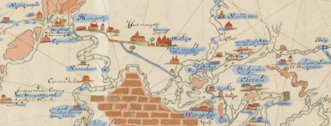
Automatically annotated map of the coast of Kerala (Nationaal Archief 4.VEL 229). The image shows visual (in red) and textual (in blue) segments that are generated automatically with the help of AI in a pilot project. They illustrate the nature of text and iconography present on maps related to Kerala.
Tools, Techniques and Objectives
This project will reintegrate data from textual archives and thirty maps on Kerala from the Leupe collection in the National Archives, The Hague to create a gazetteer of place information which includes data about their location and names these places were known by. It will also create a website which will allow users to view our data enrichments to VOC maps. For this purpose, it will use newly emerging techniques of i) handwritten text recognition (HTR) which converts handwritten text to machine readable transcriptions, ii) computer vision which automatically detects visual features like icons on maps, and iii) georeferencing techniques which help identify place coordinates on historical maps by comparing them with modern day maps.
These aforementioned techniques have, for instance, been successfully implemented by the MapReader project (UK). In the Necessary Reunions project, these techniques will be applied for the first time to an early modern corpus of maps consisting entirely of hand-written text from a global and colonial context. The gazetteer and website created by this project will allow historians to correctly identify places and better comprehend historical interactions such as why certain places were vulnerable to invasion or became trading hubs. Necessary Reunions is directly relevant to the objectives of the GLOBALISE project. The reunions project will draw on GLOBALISE transcriptions and know-how in place of dataset creation. The gazetteer created by the Necessary Reunions project can be integrated into and will enrich the GLOBALISE contextual information on Kerala.
Impact
The project will support research for writing political histories (by reflecting on the interaction of polities in relation to their location and access to resources), environmental histories (by studying changing shorelines and riverways), and socio-economic histories (in the presence of towns and ports) of Kerala. By harnessing the techniques of machine generated transcriptions and georeferencing, the project will innovatively reconcile information from both texts and maps. Once demonstrated and documented for this project, this method and techniques can be used on cartographic and textual material from other historical and geographical contexts to undertake similar initiatives. The project closely adheres to the aims of the Huygens Institute. In utilizing the VOC archives to write histories of Kerala, the project upholds the Huygens Institute’s commitment to creating inclusive histories. Furthermore, the project capitalizes on the new vistas for research that have been opened by new georeferencing tools and HTR techniques (like the Loghi toolkit developed in-house at the Huygens Institute that was used to generate the transcriptions of the VOC archives in the GLOBALISE project).
Advisors
Jos Gommans, University of Leiden
Rombert Stapel, International Institute of Social History